This day started as a typical late summer day in the central Great Plains. A mesoscale convective system had formed early in the morning in central South Dakota, and from 9-11 a.m. was characterized by a leading convective region and a trailing transition zone and stratiform region. The MCS had formed on the southern edge of a shortwave trough propagating southeastward out of southern Saskatchewan and western North Dakota.
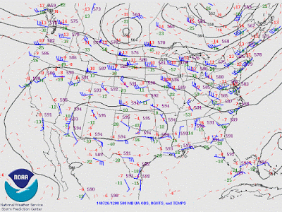 |
| 500 hPa isoheights, isotherms, and wind barbs (SPC archive). |
By noon, the thunderstorm complex had propagated into northeastern Nebraska, and the trailing stratiform region began to dissipate as the leading convective elements became more cellular. As evidenced by a special 18 UTC sounding from OAX, the environment over eastern Nebraska was characterized by weak low-tropospheric flow and moderate to strong deep layer westerly shear on the southern edge of the 500-300 hPa jet streak associated with the shortwave trough. The boundary layer below a moderate capping inversion was very warm and moist, with a surface temperature and dewpoint at OAX of 86/75 F. Above the inversion, near dry-adiabatic mid-level lapse rates were observed, leading to CAPE values in the 3000-4000 J/kg range. Given a discrete storm mode, the environment favored non-tornadic supercell thunderstorms in the northern two-thirds of Nebraska, where capping was weakest. See the observed 18 UTC OAX sounding at:
http://www.spc.noaa.gov/exper/archive/events/20140726/soundings/14072618_SNDG/last.gif
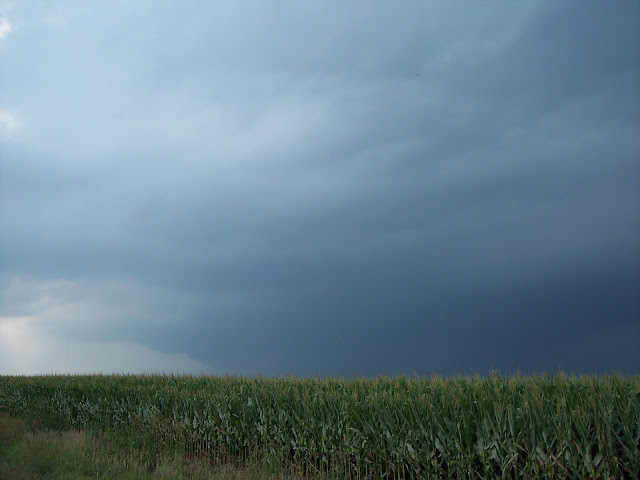
I departed Lincoln at about 1:30 p.m. northbound on NE-79, hoping to see a shelf cloud moving across the Bohemian Alps region northwest of Lincoln. Not having any mobile data on this day, all chase decisions were made by visual clues and paper maps. Sky cover was mostly cloudy as I traveled north towards Valparaiso, with little evidence of the organized convective complex which I had hoped would produce a photogenic shelf cloud. I headed west on NE-66 from Valparaiso, as the cumulonimbus towers had the strongest/most solid appearance to the northwest. As I entered Dwight, a large and robust updraft appeared to the west-northwest, as the low clouds which had been shrouding convective towers from view had abated. Figuring that the convective complex from earlier had lost organization, I decided to chase the strong looking updraft to the west, hoping that the lush vegetation and gently sculpted landscape would provide interesting contrast to what I believed were multicell storms to my west-northwest.
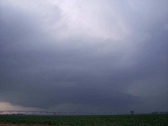
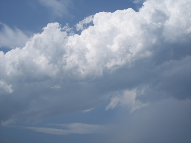
When I pulled off of NE-12C a few miles east of Ulysses, a wide, striated mesocyclone came into view.
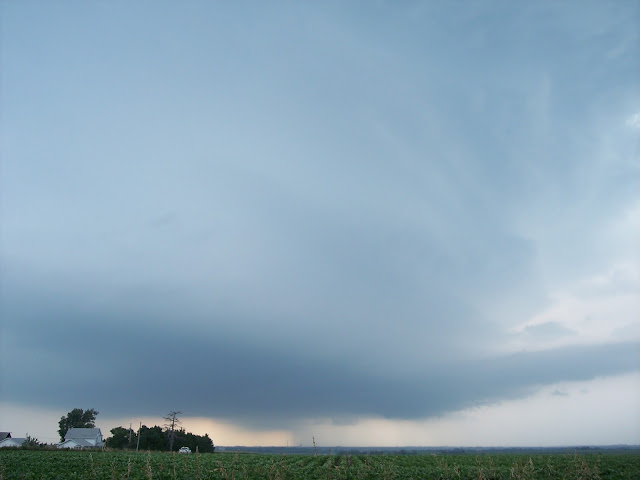 |
| Mesocyclone west of Ulysses, NE |
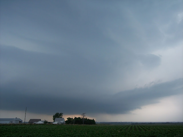 |
| Mesocyclone west of Ulysses, NE |
Not surprisingly, no low-level mesocyclone appeared to exist, likely due in part to the anemic low-level shear. Nevertheless, the storm structure was spectacular (particularly given the low expectations which I had when leaving my apartment).
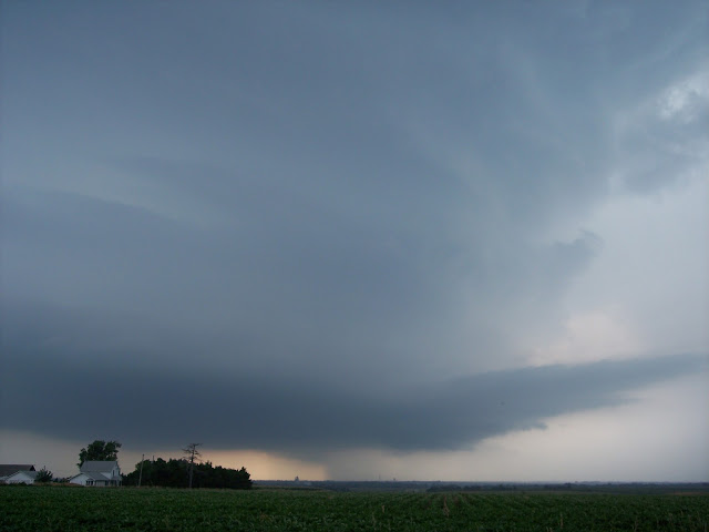 |
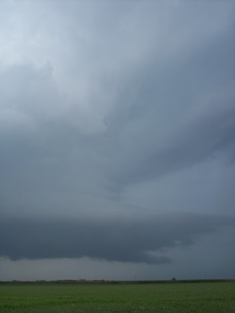
| Mesocyclone west of Ulysses, NE |
Shortly after the second photo was taken, widely spaced large drops and small hailstones began falling, as the near-updraft forward flank precipitation core moved south-southeast over me. Later that afternoon, I found out that 4.25" diameter hail had been reported to my southeast near when the above pictures were taken. I quickly re-positioned to the east and followed the storm as it moved to the south-southeast, stopping to photograph it again along NE-15 just to the south of I-80. By then, the updraft had narrowed (and likely weakened some), though it still had a sculpted appearance, as well as some evidence of a wall cloud and low-level inflow tail. Photography along NE-15 was particularly difficult, as corn stalks had become tall enough to obscure low-level storm features from view, thus limiting the number and quality of pictures of the storm as it was weakening.
 |
| The corn was too tall! |
 |
| Low-level updraft and tail cloud south of I-80 on NE-15 |
 |
| Low-level updraft and tail cloud south of I-80 on NE-15 |
As the updraft was moving too close to capture its full extent, I adjusted south to Dorchester. About 10-15 minutes after the above pictures were taken, the updraft had narrowed and weakened considerably, and exhibited a severe downshear tilt.
 |
| Rapidly weakening updraft north-northwest of Dorchester, NE |
 |
| Downshear tilted updraft north-northwest of Dorchester, NE |
 |
| Rapidly weakening updraft north-northwest of Dorchester, NE |
The formerly supercellular updraft had dramatically weakened (likely due to the stronger cap in southeast Nebraska), and no longer appeared to be producing any precipitation. Roughly 20 minutes later, after I had turned eastward towards US 77 to head back to Lincoln, all cloud cover which had been associated with the supercell completely dissipated.
This chase remains one of my favorites for several reasons: 1) Few other chasers were observing this storm, meaning that the roads were mostly devoid of traffic (as opposed to a handful of other Nebraska chases in 2014 which involved roads jam-packed with storm observers), 2) I had to rely on visual clues and my meteorological knowledge of the synoptic and mesoscale environment in order to successfully chase storms. Particularly after many frustrating, high stress chases earlier in the spring, this was a welcome experience that was likely similar to ones early storm chasers would have had in the 1970s-1990s, before mobile phone technology became widely available, and 3) I was blessed to witness the latter half of a supercell's life span (from mature stage to complete dissipation), something I hadn't seen before, and have not seen since.
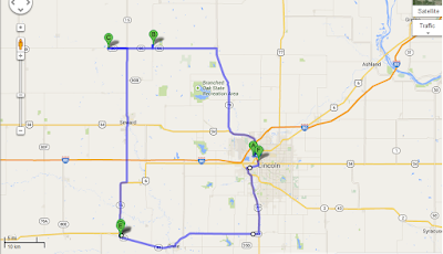 |
| Chase route |


