For part two (May 25-28), click here.
My dad and uncle Chuck and I embarked on a storm chasing and outdoors adventure during the last third of May 2021. After tentative plans to do this in 2020 were thwarted by, well, you know why, we embarked on our adventure a year later (and had a much more cooperative weather pattern for such activities this year!). As this was also intended as a hiking trip, we took a couple down days to hike or rest, including one down day that caused us to miss a localized tornado outbreak in western Kansas, and another when we skipped a tornadic supercell in southeast Colorado. Aside from never having a true blue-sky bust, my dad and uncle pretty much got the full storm-chasing experience. Details on the journey are included in this two-part blog post!
Day Zero (Wednesday, May 19): Lincoln, NE to Ogallala, NE
After I worked part of the day, my dad and Chuck left Omaha to pick me up in Lincoln and head west to a yet unknown destination. Originally, I had hoped to target southeast Montana on Thursday, until the previous evening's model forecasts started to reduce the strength and coverage of forecast surface-based instability in southeast Montana. Thus, a target area of either western Nebraska or northeast Colorado seemed like the next best play, as a deep upper-tropospheric trough began to dig into the western United States, inducing just enough upper-level southwesterly flow and low-level easterly upslope flow for severe weather into the weekend. As we drove west on I-80, we debated the merits of camping at Lake McConaughey vs Wildcat Hills (the latter would have kept northeast Wyoming as a potential target in play for Thursday). We should have been debating the merits of camping vs a hotel. Poorly timed pulse convection developed over Lake McConaughey right as we pulled up to our campsite, after we'd already paid our park entrance fee. Thus, a hotel in Ogallala it was, after we were out $18.
 |
| A sudden downpour upon our campsite which I didn't forecast |
Day One (Thursday, May 20): Pawnee Buttes, a Marginal Supercell, and Bailing Too Early (Ogallala, NE to camping near Fort Morgan, CO)
After several of Wednesday night's CAMs (convection allowing models) showed a supercell forming off of a dryline bulge in southeast Colorado, observed data in the morning and CAM trends suggested that a supercell threat would primarily be focused on northeast Colorado, with storm formation possible off the dryline near Last Chance in the late afternoon. While I wanted to target northeast Wyoming and the Nebraska Panhandle due to the picturesque terrain, forecast hodographs in these areas suggested that storms would be quite sloppy. Based on the forecast of late afternoon CI and northward moving supercells, we cruised down I-76 to Sterling, CO, then drove into the backcountry of the eastern Pawnee National Grassland to hike to the Pawnee Buttes in the early afternoon.
 |
| Getting ready to hike to the Buttes |
 |
| View of the Buttes |
 |
| We have CI to the south, as seen from the trail (storms roughly near Last Chance)! |
 |
| Kip, we need some badges before chasing. We gotta look legit; we're not nylon polymer salesmen. |
After several pictures with cows and Napoleon Dynamite poses, it was off to the developing convection down near I-70. Of course, it couldn't be that easy; we had to take a road back to CO-14 through the PNG that Google Maps claimed didn't exist. Once we were finally able to head down CO-71, the storms struggled, pulsing up and down in intensity before the expected improvement in low-level shear with the early evening onset of the low-level jet. We drove south to near Brush and waited for northward moving storms, pretty weak at that point, with some cows, throwing a baseball around as the storms passed to our north.
We followed the storms north, eventually returning to the area east of the Pawnee National Grassland. While some were marginally supercells as they moved northward towards Nebraska, they weren't much to look at.
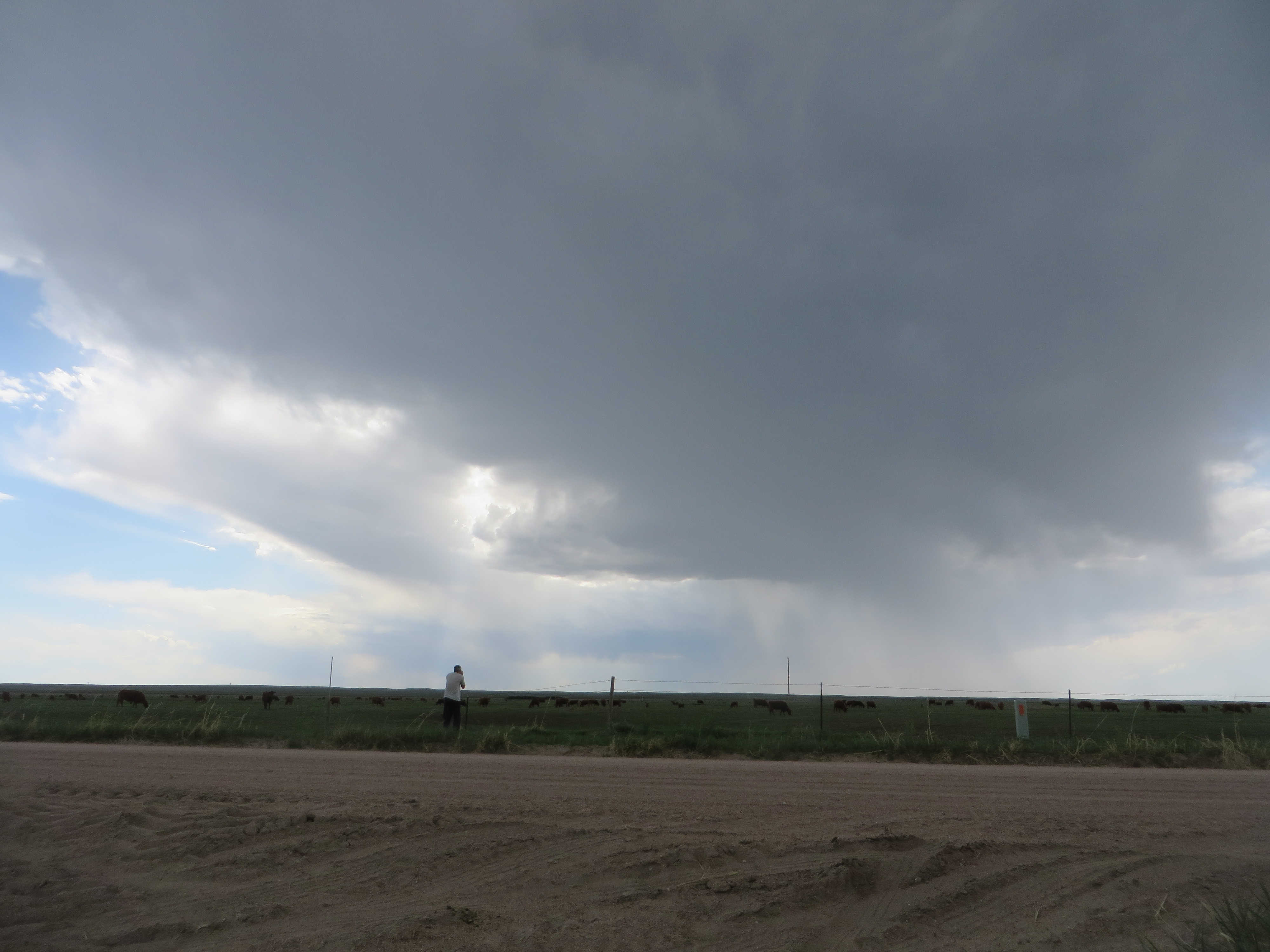 |
| Dad photographing high-based convection and cows. |
 |
| It was a marginal supercell, but ... meh. |
Sadly, my camera also reverted to a mostly unusable form of manual mode this afternoon, in which it remained for the rest of the trip. This made time lapses very difficult to shoot if I wanted any of the individual pictures to be decent quality, so I had to start shooting in automatic mode to optimize depth-of-field and lighting, resulting mostly in single images, rather than time lapses, for the rest of the trip.
Rather than stay in the area and wait for more storms to the south, I bailed and found lodging for the evening, going against my forecast that storms might take on more interesting structure early in the evening, due to a rapid enlarging of the low level hodographs as the low-level jet kicked in. Predictably, as we approached our campsite at a nearby park, I looked over my shoulder at beautiful LP structure forming on the northern Colorado storms in the early evening. Here's a picture of this storm, taken by Mike Umschied (Northeast Colorado LP Supercell).
After making the campsite reservation (which was a massive headache due to poor cell coverage, among other things), we pitched our tent among massive mosquitoes and winds gusting to near 40 mph. At the end of the trip, Chuck admitted that he thought the buzzing noise he heard as we went to sleep was traffic on I-76. The following morning, we realized in horror that the sound was of mosquitoes swarming our tent, ready to feed on us when we got up. Somehow, though, I managed to sleep great that evening, a rarity for me while camping.
Day Two (Friday, May 21): Mosquitoes, Mount Olympus, and Splitting Supercells (Fort Morgan, CO --> Estes Park --> Sidney, NE)
With mosquitoes swarming, we needed a strategy to exit the tent while limiting the amount that we'd get eaten. Our strategy was executed with precision, as we rapidly exited, closed, and broke down the tent. Regrettably, we hadn't considered keeping the minivan shut. We left the park at about 6-7 MT, westbound for an early morning hike in the Rockies, and we were still killing mosquitoes in the van all the way to Estes Park.
Figuring that we had time to complete a 2-3 hour hike in the morning before a possible northeast Colorado chase late in the afternoon, we headed up US 34 along the Big Thompson River to the Mount Olympus trailhead near Estes Park, in the heart of Arapaho and Roosevelt National Forests. This was a fantastic but difficult hike, with incredible 360 degree views of surrounding 14ers from the top, including Mount Evans.
 |
| Up US 34 to Estes Park |
 |
| On the way up, looking down towards Estes Park |
 |
| We made it! |
A few words about the hike: 1) Since we didn't plan this hike in advance, we hadn't eaten much as a group; only a few poptarts per person in the van that morning. This was before a hike with a ~1400 foot elevation gain, at high elevation, while barely being acclimated. I had waves of physical exhaustion and nausea come over me about halfway up the trail. I was definitely hydrated, wasn't overheating, and didn't have any other symptoms of altitude sickness. Thus, I quickly came to the conclusion that, like my friend Jason on our trip to Colorado the previous fall (Dark Canyon, Irwin Lake, and Dyke Trail (Colorado Fall 2020 Day 3)), mistakes had been made. Drinking a sugar-filled protein shake at the summit and almost immediately returning to normal confirmed my suspicion that I had been suffering from low blood sugar. 2) Cairns are a great navigation tool, with which hikers can show future hikers where a trail leads in areas where it's not otherwise obvious. However, they can also be quite confusing if one constructs them in locations where the trail is not. The latter, unfortunately, was all too common on this trail, which ultimately led to us needing to scale our way down boulders near the bottom of the trail after incorrectly placed cairns had led us off of the trail, despite me tracking our progress using the AllTrails app.
When we got back to the car, I had a short period of time from our exit from the cell-signal-less region of the Rocky Mountain Front Range until Interstate 25 to make a call on chasing northeast Colorado (near Sterling again) or positioning south for an unusually spicy looking supercell setup in central New Mexico on Saturday. Ultimately, I was convinced that a combination of chasing Friday, Saturday, and Sunday afternoons in northeast Colorado and adjacent areas was more likely to net a good result than a single day in New Mexico, as enticing as chasing there for the first time was at the time (thankfully, we'd be enchanted by New Mexico later in the trip). We drove back to Sterling and waited for initiation to our south from Columbine Park, where we used the swing-set and ate a late lunch of peanut butter sandwiches and apples. SPC had a 5% tornado outlook in our area and a 15% hatched hail risk, which looked like a reasonable forecast. Despite deep layer meridional flow, there seemed to be decent chances to get one or more northward moving tornadic supercells. For the second consecutive day, I was wrong.
A storm initiated to our south and gradually took on supercell structure; however, before initiation, the cumuloform clouds in the boundary layer still appeared to have weak buoyancy, as they were likely fighting a strong cap. This was probably why only weak supercells developed this afternoon. Given relatively straight hodographs in the region where most storm inflow was occurring (I suspect that the storms were slightly elevated, in addition to being high-based), storm splits were common early on in convective evolution. On the gravel road in the picture below, I did a quick demonstration on how to read a hodograph to anticipate cell splits, using rocks and lines in the dirt!
 |
| Weak, anticyclonic supercell (left split) approaching an abandoned house near Illif, CO |
 |
| Freight train going through Peetz, CO |
 |
| High-based convection south of Peetz, CO |
 |
| Lunch-time at Memorial Park |
Convective initiation became imminent to our south, and a tornado watch was issued, so we headed south from Sterling towards Akron. Several north-northeast moving supercells formed along and near the boundary as we were driving south. The strongest one, located to our southwest as we passed I-76, started to gain more rotation. Given a likely large amount of crosswise vorticity above a kilometer or so AGL, rotation in the supercell wasn't visually obvious. However, as we approached Akron on CO-71, a large funnel cloud appeared out of the south side of the updraft base. Within 30 seconds, it was obvious that this was a tornado. We pulled onto a gravel road adjacent to the municipal airport, and I frantically yelled to my dad to start taking pictures, as the tornado was already beginning to rope out when we pulled off the road.
 |
| Akron, CO Tornado |
 |
| Akron tornado roping out |
After the tornado dissipated, more photography opportunities quickly arose. Two crop dusters, in succession, landed on the runways, right in front of us, with a wall cloud in the background (which did not produce another tornado while we were on the storm).
 |
| Wall cloud on Akron supercell |
 |
| Crop duster landing in front of Akron supercell |
 |
| Second crop duster preparing to land in front of the Akron supercell |
Other storms developed immediately to our south and presented a large hail risk. Our only good escape route from these new storms was to scoot north on CO-71 and then ~5 miles east on a gravel road, which, given the quick storm motions, took us out of position to keep up with the initial storms as they raced northeast towards Nebraska. As a consolation prize, the departing storms provided for very photogenic scenes in the abnormally lush Colorado high plains.
 |
| Calm after the storm |
 |
| New updrafts and pileus south of the Akron cell, now racing towards Nebraska |
 |
| Backside of the Akron cell |
Given opportunities in northeast Colorado and southwest Nebraska to attend Pentecost Mass on Saturday evening, we tried to catch up to the initial convection when it was east of Sterling, rather than chase the Punkin Center tornadic supercell which developed between Colorado Springs and Pueblo (given its quick northeast motion, it would also have been reachable). By the time we reached the storms east of Sterling, near Haxtun, they had moved into stable air north of the boundary. Still, the grain elevator in Haxtun provided more photo opportunities, and we made it to 5 p.m. Mass in Haxtun.
 |
| Cells moving north of boundary, to the north of Haxtun, CO |
 |
| Mass in Haxtun, CO |
Finally, after Mass, we booked a hotel in Burlington, and went south on US 385. A nicely colored shelf cloud greeted us on the southward journey near Wray.

Days 4 & 5 (Sunday, May 23 & Monday, May 24): Windswept Plains, Wishful Thinking, Western Skies, Woeful Forecasting, and Walking off Missed Kansas Storms (Burlington, CO --> Goodland, KS --> Omaha, NE)
We awoke Sunday morning to partly cloudy skies and northward screaming low-level clouds. A negatively tilted mid-level trough was moving eastward and about to eject into the central and northern high plains, with a powerful shortwave trough near its base early in the morning. With at least three consecutive days' worth of low-level upslope flow into eastern Colorado, low-level moisture appeared primed for convection on the eastern Colorado and western Kansas plains. With the ejecting trough leading to strong lee cyclogenesis, low- and deep-layer shear profiles were forecast to be very favorable for tornadic supercells by late afternoon and especially early evening (with the strengthening of the low-level jet), assuming a favorable convective evolution for discrete storms. CAM solutions, as usual, were all over the place, but the early (12-18 UTC(ish)) runs of the HRRR matched my conceptual forecast model for the day: 1) Early afternoon initiation would take place west-southwest of Limon, CO, due to elevated heating along the Palmer Divide and confluent flow along a bent-back dryline. While low-level shear wasn't overly strong yet, these storms, like yesterday's, would likely present a tornado risk within a zone of strong surface-based instability and vertical vorticity within the Denver Cyclone Vorticity Zone. These cells would likely be supercells initially, given the favorable combination of instability, deep-layer shear, and mean flow roughly perpendicular to the initiation axis. Given the strong, south-southwesterly mean flow, they would likely race quickly to the northeast. 2) As the mid-level trough axis pivoted eastward, the dryline would tighten in east-central and southeast Colorado, given an expected dryline bulge off of the Raton Mesa and continued moisture advection from the southeast. Given more westerly, and slightly weaker, flow on the south side of the trough, storms initiating off the dryline bulge would likely be supercells (again, favorable instability/shear combo, somewhat perpendicular mean wind/dryline orientation in southeast Colorado). These cells, as they matured during the late afternoon and early evening, would move into a favorable deep-layer and low-level shear environment for tornadoes, some possibly significant, as the low-level jet strengthened. With convective inhibition gradually strengthening and the concave shaped hodographs, potential for highly photogenic storms was also apparent. Given that chasing scenario 1 would be a headache due to fast storm motions, and could take us out of position for scenario 2 farther south, we were patient.
We started the afternoon at a park in Burlington, ate lunch, threw a baseball, and then drove to near Siebert. We watched a supercell form near Limon race to the northeast, which produced a few tornadoes near Akron, where we had been the day before. I was still hopeful that more storms would form on the dryline farther south, so we waited as gusty surface winds buffeted our parked minivan. In Siebert, we ran into chaser convergence at a gas station, and I ran into a friend from college, Stephen, on a gravel road! After catching up with him, we adjusted east to Burlington, as cells developing in southeast Colorado on the dryline strengthened and moved towards us. Two cells in particular began to look like supercells on radar. Given the environment that I thought the storms would be moving into, wanting to avoid US 385 between Burlington and Wray, with its lack of east road options and poor cell coverage, we headed east on I-70 to Kanorado, then Goodland, before turning north well to the east of the storms. As we did this, surprisingly, none of the storms strengthened. They generally did not remain discrete, and failed to become strong supercells. I told my dad and Chuck that I wanted to play chess with the storms by jumping ahead to Kansas. Instead, we waited for hours for any storms to take over.
While at our spot (a beautiful high point where you could see for tens of miles to the west and north), a local farmer stopped to say hello a couple times, before and after tending his livestock. A few years prior, he had seen one or more of the June 8, 2019 tornadoes from the spot we were sitting at. My friend Matt is doing analysis of drone and other in situ data collected on this storm during the first year of the TORUS field project. With the strengthening low level shear, one storm morphed into a supercell near the southern end of a developing line moving from eastern Colorado into northwest Kansas, while the northern portion of the line (near St. Francis, KS) rapidly developed a hook echo and, perhaps, a brief QLCS tornado. Watching these processes from afar, and a beautiful sunset, was still rewarding, despite my expectation of getting to see powerful supercells that evening.
 |
| Rapidly advancing precipitation, with scud to the right, looking NW towards St. Francis, KS |
 |
| Vivid sunset colors through distant rain. Sadly, I couldn't quite get the camera to steady |
 |
| Line and semi-discrete storm approaching from Colorado |
When the last shades of daylight faded, my ability to forecast faded alongside, and we made the biggest mistake of the trip. We needed to return for a down day in Omaha by mid-afternoon on Tuesday, May 25 for a family event, and with only a slight risk out for the 24th in western Kansas with seemingly a marginal chance for supercells, driving back to Omaha into the night was enticing. I took 10 minutes on the gravel road to read the Goodland and Dodge City AFDs, and looked at the 0 UTC HRRR and 3 km NAM updraft helicity tracks, neither of which showed anything worth chasing the next day. We abandoned our plan to stay the night in Goodland in favor of making the trek to Omaha, and drove through Selden, KS (this became painful the next day), while enjoying podcasts on political philosophy and an Amon Sul Podcast episode on Brad Birzer's JRR Tolkien's Sanctifying Myth.
I awoke in a spare bedroom at Grandma's house around 10 a.m. and checked the latest SPC convective outlook. Nothing had changed yet, but when I looked at visible satellite and surface observations after breakfast, I realized that my Kansas storm-chasing plight was again at work. An east-west oriented outflow boundary from last night's storms was draped across west-central Kansas, with a surface low developing to the west. Deep-layer shear was already favorable for supercells, and low-level shear near the outflow boundary indicated tornado potential. We were 5-6 hours away, but if we had kept our plan to stay in Goodland the night of the 23rd, we'd have almost certainly decided to stay in western Kansas on the 24th. To ease the frustration and get some needed exercise, my dad and I took a hike around Memorial Park and visited St. Margaret Mary Catholic Church near the UNO campus. Meanwhile, slow moving and extremely photogenic supercells and tornadoes prowled about the western Kansas landscape. As frustrating as another busted Kansas forecast was, after this, our decision making for the second half of the trip became much more confident, my forecasting improved, and we'd be treated to several gorgeous supercells, a great hike at Palo Duro Canyon, and finally, my first Kansas tornado (see part two).
 |
| St. Margaret Mary Church, Omaha, NE |