On an early Spring Saturday morning, I awoke in my west-facing room, just southwest of Lincoln, NE, and immediately felt a damp chill. Unseasonably warm air hours before had enticed me to leave my window open, but when I rolled out of bed, I was the coldest I can remember being on the morning of a nearby storm chase. At about 11 p.m. the previous night, the atmosphere had jumped ahead a season; it was warm and humid outside, and my housemates and I heard rolling thunder in Lincoln for the first time since the anomalous December 15 (2021) derecho and tornado event. Since the December derecho, we had had one of our driest and least snowy winters on record going into early March, with similarly dry short-term weather (~3ish months) across much of eastern and central Nebraska and parts of adjacent states. Evening and overnight thunderstorms delivered locally up to an inch of rain, which was welcomed by local farmers. But by morning, the warm, humid air and thunderstorms had given way to fog, mist, and light rain, with temperatures riding the early spring roller coaster back down to the 40s.
Despite the cold outside as I headed to early morning Mass, I still had a nagging excitement about supercell and tornado prospects that afternoon. A powerful negatively tilted upper-level trough was impinging on the central Great Plains, and a surface low pressure area was forecast to quickly develop along a slowly moving cold front, which had now pushed slightly east of Lincoln. Dewpoints approaching 60 F were possible near the triple point that afternoon, and hodograph shapes seemed to favor photogenic tornadoes. My girlfriend and I had a hockey game date night that Saturday evening, and I needed to be in Lincoln at 5:30 to go to that. With the cold front having already pushed through Lincoln, the chances that the warm sector would be close enough for chasing in the afternoon, given the time constraints, seemed slim. But after feeling the spring airmass the night before, I couldn’t help giving southwest Iowa a try in the early afternoon, just in case.
I headed to Harbor Coffeehouse after Mass to meet up with my friend Tessa and to start looking at weather data. As I had hoped, the cold front had slowed to a crawl just east of Lincoln. Despite being socked in rain and clouds locally, visible satellite imagery revealed clearing skies in northeast Kansas and far southeast Nebraska. Through the early afternoon, it seemed likely that clouds would continue to mix out further northeast in southwest Iowa, as long as morning convection stayed away from the NE/IA/KS/MO border area. Mid-level cooling ahead of the upper-level trough due to strong large scale ascent, combined with the expected surface heating and observed pooling of upper 50s/low 60s dewpoints in southwest Iowa, made appreciable surface-based instability likely to develop by 1 or 2 p.m. in extreme southeast Nebraska and southwest Iowa. Regional surface observations revealed a surface low in north-central Kansas, which would head northeast and deepen in eastern Nebraska and western Iowa, helping to keep surface winds backed in some areas. The main questions were when storms would initiate and how quickly they’d mature into supercells, given the combination of strong wind shear and low instability. By 11 a.m., I was confident in convective initiation (CI) near the Missouri River floodplain by 2 p.m., so I gassed up and went east on Nebraska Route 2 for lunch in Nebraska City. Somewhere near Syracuse, all of my windows rapidly fogged up. I was back in the warm sector, and I was quite happy to be there.
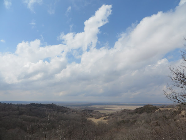
After a bite to eat in Nebraska City, I headed to Waubonsie State Park, just across the river in Iowa, to time lapse CI from an overlook of the Missouri River flood plain from a ridge in the Loess Hills. At about 1 p.m., sunshine was only occurring in pockets, but over the following hour, sunshine became more widespread, the cumulus towers became crisper, and CI became imminent.
 |
| Congested cumulus field developing around 1 p.m., looking west from Loess Hills @ Waubonsie State Park, IA |
 |
| Cumulus field developing more vertically, around 1:40 p.m., looking west from ridge of Loess Hills @ Waubonsie State Park, IA |
Finally, the towering cumulus deepened further, and frequent thunder rolled across the valley and up into the hills. It was time to go.
 |
| Storms have initiated now, about 2 p.m., looking west from ridge of Loess Hills @ Waubonsie State Park, IA. The leftmost updraft in the foreground (see impinging gray clouds), now producing lightning, ultimately became the target storm. |
I headed east out of the park on Iowa Route 2 and meandered north on US 275 towards Sidney, then went northeast from there. A crisp, but otherwise unremarkable storm base, followed to my southwest. I knew that storms would take a bit of time to organize, but the evening time constraint and fast (~50 mph) northeast storm motions convinced me to stay closer to storms, rather than my normally more patient approach to chasing. I pulled off of County Road 330 about 4 miles south of Randolph to watch the storm to my southwest.
 |
| Nice bases, but not consolidated yet, taken ~4 mi south of Randolph, IA looking west ~ 2:15 p.m. |
 |
| Base, still mostly disorganized, ~ 4 mi south of Randolph, IA, looking west ~2:20 p.m. |
Another supercell was quickly developing to the south-southwest and was beginning to appear stronger on radar imagery than the original target storm, pictured above. It also had the benefit of a less impeded inflow area, being to the south of the original target. I pivoted away from following the initial target northeast, in favor of going north to IA 184, then heading east to US 59 just east of Imogene, so that I could go a few miles back south and wait for the southern supercell to reach me. A severe thunderstorm warning, the first warning of the day, was issued for the southern supercell as I headed north to Randolph. Once I got east of Imogene, it became clear that I’d miscalculated the relative speeds of the storm and myself. I was now in the throes of the forward flank precipitation of the southern supercell, which was moving northeast at about the speed limit (55 mph) of IA 184. A couple minutes later, a faint ping, ping, ping, and small bits of ice ricocheted off of my windshield. Thankfully, I soon reached US 59, which offered a direct northward option before the hail got larger. Faced with either bailing on the southern supercell or getting stuck in its core with possible wind-driven destructive hail, I bailed north. Very soon, I’d be thankful to the southern storm’s hail core for forcing me to do so.
Once I got out of the southern storm’s forward flank, the visual and radar structure of the northern (original target) storm improved, and I was still pretty close to it. Reflectivity and reflectivity gradients both increased as the northern storm gained more separation from the southern one. As a quick aside, my camera lens started to have issues opening properly … at the worst possible time.
 |
| Improving structure on the northern cell, now several miles south of Emerson, IA. |
 |
| Wall cloud beginning to develop, with beautiful tilted updraft, south of Emerson, IA |
Once the above wall cloud developed after I’d pulled off of US 59, things happened fast (figuratively and literally speaking). South-southwesterly winds quickly strengthened, as the low-level mesocyclone raced northeast while I watched from the rear-flank. Then, a powerful rear-flank downdraft developed as the low-level mesocyclone began to consolidate. Clouds in the rear-flank of the updraft began a rapid cascading motion, and tornadogenesis appeared to be imminent.
| Quickly evolving low-level mesocyclone, possible funnel cloud, and wall cloud south of Emerson. |
 |
| Supercell racing northeast towards Emerson, IA,
viewed from rear-flank on US 59 looking north |
 |
| Supercell racing northeast towards Emerson, IA, viewed from rear-flank on US 59 looking north. |
As best as I could tell, no tornadoes had yet touched down (no dust whirls were apparent under any of the candidate funnel-like appendages). The storm continued to race to the northeast, so I followed it a few miles farther north on US 59 before pulling off again. While I was driving, the upper-left to lower-right cascade motion in the rear-flank cloud tags made me feel tiny in my little sedan. It is easy to exaggerate perceived wind speeds and “violent motion” in mesocyclones before tornadogenesis, but it had been over 5 years since I’d seen anything like this (the perspective from the rear-flank of the May 24, 2016 Akron, CO supercell was my only similar experience).
After pulling off US 59 onto a gravel road a few miles south of Emerson, the storm structure became even more striking. The rapid motion in the RFD continued, and wind-blown hail and rain was apparent just to my north. The storm’s rear-flank was awesome enough as a roiling mass of dark gray and white clouds and hints of a rainbow soon to come. But then, a light gray colored rope tornado was briefly unveiled. Maddeningly, my camera lens wouldn’t open properly:
 |
| Lower-center, brief rope tornado still visible, looking north from a few miles south of Emerson, IA. |
Beautiful rear-flank structure continued, with either a second tornado or the first one becoming visible again, next to a developing rainbow. Based on video footage taken by others who were closer, and multiple reports, there was at least one tornado, though I haven't seen any video of the apparent fully condensed tornado that I saw (sometime between 3:00-3:05).
| Emerson, IA supercell rear-flank |
 | |
| Emerson, IA supercell rear flank |
 |
| Apparent tornado, perhaps the same one as before, with developing rainbow, viewed from south a few miles south of Emerson, IA, roughly between 3 and 3:05 p.m. |
 |
| Tornado dissipating, with rainbow becoming more visible, viewed from south of Emerson, IA |
 |
| Tornado dissipating, with rainbow becoming more visible, viewed from south of Emerson, IA |
A few minutes later, I started back north on US 59 to try to keep up with the supercell. However, I came across a small area of damage, where some folks had set up a road block by a downed power pole and line at the southern edge of Emerson. There was some other scattered debris in the area as well. By time I was able to get to US 34, the Emerson supercell was out of reach, given the fast storm motions.
 |
| Decaying supercell north of Stanton, IA |
I followed US 34 east while also setting my route back to Lincoln to keep track of the time. Upon reaching Stanton, IA, several tornado-warned supercells were nearby, each crossing the highway from southwest to northeast. The western of these was weakening as it went north of 34, and I found a high point near town to watch it and the storm crossing the highway to the east. Neither produced any tornadoes visible from my position, and the one north of the highway was quickly weakening, though it provided for a nice timelapse in its decaying phase.
After time lapsing this storm, it was off to Lincoln. On my journey westward, US 34 climbed a ridge into a bright, but cold, mist. After being in spring for 4.5 hours, it was a boundary that I begrudgingly crossed, particularly when the brightness of the March sun gave way to a thick gray as I travelled deeper into the cold.